Question 1: Use the appropriate formula to convert the following temperatures. Feel free to use this handy temperature calculator by the National Weather Service: http://www.srh.noaa.gov/epz/?n=wxcalc_tempconvert
20°C = -6.67 °F
-25°C = -13 °F
59°C = 138.2 °F
72°F = 22.22 °C
98.6°F = 37 °C (body temperature)
0°C = 273.15 °K
Question 2: Analyze the meteogram from New Orleans, LA (KMSY) below and answer the following. Remember that time is in UTC at the bottom.
- What time (New Orleans time) was the warmest temperature reading for September 12, 2012? 17Z
- What was the daily mean temperature on this day? 81.3°F
- What was the daily temperature range on this day? 12.5°F
Salt Lake City, Utah (Continental interior location)
Jan | Feb | Mar | April | May | Jun | Jul | Aug | Sept | Oct | Nov | Dec |
28 | 34 | 40 | 50 | 58 | 67 | 76 | 74 | 65 | 53 | 38 | 32 |
Yearly Mean Temperature 51.2°F
Yearly Temperature Range 48°F
Los Angeles, California (Coastal location)
Jan | Feb | Mar | April | May | Jun | Jul | Aug | Sept | Oct | Nov | Dec |
55 | 57 | 59 | 59 | 64 | 68 | 70 | 73 | 72 | 65 | 63 | 59 |
Yearly Mean Temperature 63.7°F
Yearly Temperature Range 18°F
Miami, Florida (Coastal location)
Jan | Feb | Mar | April | May | Jun | Jul | Aug | Sept | Oct | Nov | Dec |
66 | 68 | 70 | 73 | 77 | 80 | 82 | 82 | 81 | 77 | 70 | 68 |
Yearly Mean Temperature 74.5°F
Yearly Temperature Range 16°F
Fairbanks, Alaska (Coastal location near arctic)
Jan | Feb | Mar | April | May | Jun | Jul | Aug | Sept | Oct | Nov | Dec |
-11 | 0.5 | 10 | 27 | 47 | 59 | 60 | 55 | 44 | 26 | 4 | .7 |
Yearly Mean Temperature 26.85
Yearly Temperature Range 71
Moscow, Russia (Continental interior location)
Jan | Feb | Mar | April | May | Jun | Jul | Aug | Sept | Oct | Nov | Dec |
14 | 15 | 24 | 40 | 53 | 62 | 66 | 63 | 52 | 40 | 29 | 20 |
Yearly Mean Temperature 39.8°F
Yearly Temperature Range 52°F
McMurdo Station, Antarctica (Continental interior location in Southern Hemisphere)
Jan | Feb | Mar | April | May | Jun | Jul | Aug | Sept | Oct | Nov | Dec |
24 | 15 | 5 | -9 | -11 | -12 | -15 | -15 | -12 | -2 | 14 | 25 |
Yearly Mean Temperature 7°F
Yearly Temperature Range 40°F
Benghazi, Libya (Continental interior location in Sahara Desert of Africa)
Jan | Feb | Mar | April | May | Jun | Jul | Aug | Sept | Oct | Nov | Dec |
55 | 57 | 63 | 66 | 72 | 75 | 78 | 79 | 78 | 75 | 66 | 59 |
Yearly Mean Temperature 68.6°F
Yearly Temperature Range 24°F
Question 4: Go to NOAA’s website at http://www.ncdc.noaa.gov/oa/climate/globalextremes.html#hightemp to analyze historical temperature and precipitation extremes globally. List the three hottest places ever recorded in the world.
Continent | Temperature | Place | Elevation | Date |
Africa | 136 | El Azizia, Libya | 367 | 13 Sep 1922 |
North America | 134 | Death Valley, CA (Greenland Ranch) | -178 | 10 Jul 1913 |
Asia | 129 | TiratTsvi, Israel | -722 | 22 Jun 1942 |
List the three coldest places ever recorded around the world.
Continent | Temperature | Place | Elevation | Date |
Antarctica | -129 | Vostok | 11220 | 21 Jul 1983 |
Asia | -90 | Oimekon, Russia | 2625 | 6 Feb 1933 |
Asia | -90 | Verkhoyansk, Russia | 350 | 7 Feb 1892 |
Question 5: The heat index and wind chill is a way to compare temperature in relation to human senses. The heat index compares the relationship between temperature and humidity. The warmer the temperature and the higher the humidity, the hotter it will “feel” to humans. Go tohttp://www.srh.noaa.gov/jetstream/global/hi.htm to analyze heat waves.
- Temperature = 100°F & Relative Humidity = 40% => Apparent Temperature = 110°F
- Temperature = 100°F & Relative Humidity = 60% => Apparent Temperature = 130°F
- Temperature = 30°F & Wind Speed = 0 mph => Wind Chill = 30°F
- Temperature = 30°F & Wind Speed = 15 mph => Wind Chill = 19°F
- Temperature = 15°F & Wind Speed = 20 mph => Wind Chill = -2°F
- Temperature = 0°F & Wind Speed = 20 mph => Wind Chill = -22°F
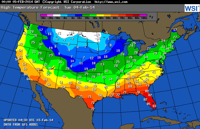
High Temperature: http://images.intellicast.com/National/Temperature/HighTomorrow.aspx
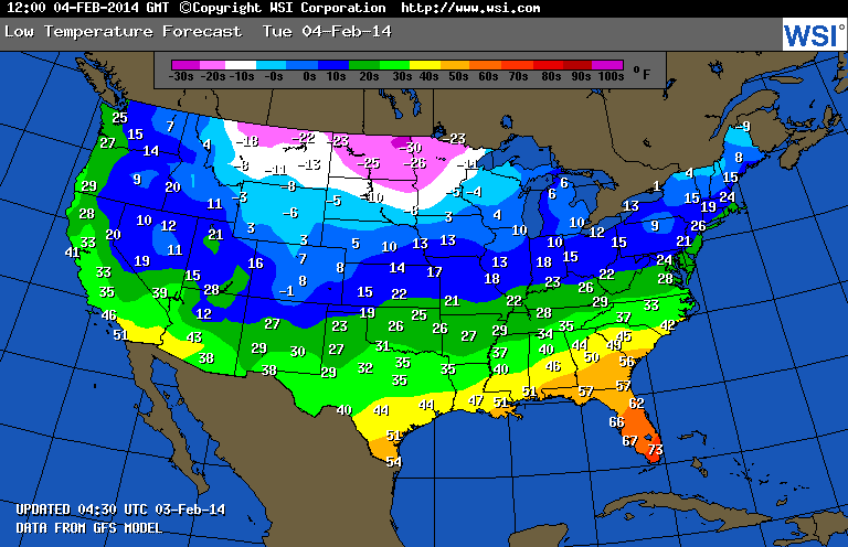
Low Temperature: http://images.intellicast.com/National/Temperature/LowTomorrow.aspx
Determine a location on the map you would like and find a Station ID for that location. Find a Station ID for your chosen location athttp://www.rap.ucar.edu/weather/surface/stations.txt. Remember, it should be a four-letter code usually starting with the letter “K” if it is within the lower-48 states.
- What is your chosen location (city and state)? Buffalo, Wyoming
- What is its station ID? KBYG
- Right click on the high temperature image and select “Save Picture As…” or “Save Image As…” and save the image to your computer. Save your high temperature map as HighTemperature and your low temperature map as LowTemperature. The weather model forecasts the high temperature to be -1°F and the low temperature to be -6°F. Label appropriately with the degrees Fahrenheit. You will upload these images into your SLCC ePortfolio.
- Now wait 24 hours. Once 24 hours have passed, go to the NWS climate website at http://www.nws.noaa.gov/climate/. You will see a map of temperature readings; click on your location (or the closest one to your chosen location).
- Clicking on your location will bring up a new website (allow for pop-ups). Make sure the Product is the Daily Climate Report, the Location is your chosen city, and the Time Frame is one day (not more or less) after you looked at the high/low temperature forecast. Click GO.
What was the maximum temperature and time for your chosen location? 15°F 1:47pm (20:47 UTC)
What was the minimum temperature and time for your chosen location? 3°F 11:59pm (6:59 UTC)
What was the average temperature for your chosen location? 9°F
Assignment Reflection
This class has allowed me to dramatically improve my scientific thinking in regards to meteorology. I have learned about the thermal structure of our atmosphere and the layers that create it. Learning about the heating of Earth's atmosphere has been a tool in teaching me how to think about meteorology in a more scientific manner. The fact that we have learned about the solstices and the equinoxes has been very enlightening. Before this course, all I knew was that on those days, the seasons officially changed. I knew it had something to do with the Earth's position but that's really all I knew about that. Learning about heat transfer has definitely improved my way of thinking. I hadn't given much thought to the fact that there are various types of heat transfer (conduction, convection, radiation). I found myself fascinated while reading in our text about the electromagnetic spectrum and wavelengths. Yet, the way it was illustrated in our reading allowed me to grasp the concept better than when it has been explained to me in the past. We have also learned about what happens to incoming solar radiation from our sun. As our Earth changes with its warming trend, knowing how solar radiation works is becoming more crucial than ever. Regardless of whether or not you're designing a solar panel or any other type of Earth instrument, we need to know how solar radiation works so that we can continue to make wise choices in regards to energy efficient living.